Showing posts with label Google Maps. Show all posts

Saturday, May 21, 2011

More Features in Google Maps for Mobile Browsers

One of the most underrated Google mobile Web apps is Google Maps. Most smartphones and tablets have a native app for Google Maps, so a mobile Web app doesn't seem necessary. Unfortunately, native apps aren't always updated frequently and there are many missing features. Google does a good job at updating Google Maps for Android, but Apple's Maps app for iOS rarely includes new Google Maps features.

That's probably one of the reasons why the Google Maps mobile site was updated to include most of the features from the desktop site. Another reason is that Google wants to offer "a consistent Google Maps experience wherever you use it."

The updated Google Maps mobile site has features like local business search, Google Places, driving directions, layers, My Maps, starred locations, search suggestions. If you can't find biking directions or information about businesses in the Maps app for the iPhone, you can go to maps.google.com in your mobile browser and use these features.


Just like the mobile YouTube site, "Google Maps for mobile browsers is platform independent - you will always get a consistent experience and the latest features without needing to install any updates, no matter what phone you use."

I've tried the updated mobile interface on an iPhone 3GS, a Nexus One and an iPad 2. While all the new features are great, the site is still too slow and unresponsive to be useful. Until Google solves performance issues and mobile browsers become more powerful, people will still use the native app.

Thursday, May 19, 2011

Google Maps OneBox Outlines

Google's OneBox displayed when you search for the name of a country, a city or a zip code got smarter. Google added an outline around the location you want to find, so the map is even more useful. For example, try searching for [Bronx], [Detroit 48238], [Baku], [Paraguay map].

Chris, a reader of this blog, says that he used CityData before noticing the new Google feature. While CityData is only useful for the US, the Google Maps OneBox is displayed for almost any city in the world.


{ via Search Engine Land. Thanks, Chris. }

Wednesday, January 19, 2011

New Google Maps Navigation Controls

After more than three months of testing, the new Google Maps navigation controls have replaced the classic tabs. By default, Google shows a small preview of the satellite imagery and a link to the traffic layer, but you'll get more options if you mouse over "satellite" or "traffic".


Google lists the layers that are available (terrain, webcams, the confusingly named Buzz, videos, Wikipedia, bicycling, real estate, transit, 45 degree imagery, labels), including a list of previous searches and driving directions.


"When we launched Google Maps, we had one layer -- the map. Since then, we've added more than ten different ways to explore the world around you, including photos, transit and traffic information, as well as satellite and terrain views. We've now updated the design so that you can more easily see and switch between the various viewing options that are available," explains Google.

I find the new interface more confusing, but I admit that it will better accommodate the new layers that will be released. Until now, if you wanted to switch to the satellite mode, you clicked the "satellite" button and that was it. Now Google shows a lot more options when you mouse over the button and you might even forget what you wanted to do.

Thursday, December 16, 2010

Google Maps 5 for Android: 3D Maps and Offline Caching

Google Maps 5 for Android comes with two features that make Google's mapping software a lot more useful. Google now uses vector graphics instead of map tiles and it caches some of your most frequently used maps so that they are available offline.

Vector-based maps allowed Google to add a lot of cool gestures:

Tilting: Drag down with two fingers to tilt the map. Tilt while zoomed in on one of the 100+ cities around the world with 3D buildings to see a skyline spring to life.

Rotating: Twist with two fingers to rotate the map. After tilting to see 3D buildings, rotate around them to gain a new perspective from any direction.

Smooth zooming: Slide two fingers together or apart, and see the map and labels continuously scale to any zoom level, stopping when your fingers stop.

Compass mode: Center the map on your location, and then tap the compass button in the top right corner. The map will flip into 3D mode and start rotating to match your perspective, while still keeping all the labels upright and readable.


The new 3D view makes maps more intuitive and easier to use, but that's not all. Since Google no longer has to download map images from its servers and vector-based maps require 100 times less data for all zoom levels, it's feasible to cache data. "Rather than having a static set of maps when installed, Maps will automatically start caching the areas you visit the most when your device is plugged in and connected to WiFi (e.g., the nightly charge)." You can't manually control caching, but it's an important first step toward an offline Google Maps.

Google also promises to add offline rerouting to Google Maps Navigation. "You'll still need a connection to start a route, but if you miss a turn along the way, we'll quickly get you back on track, even if you don't have an Internet connection."

Google Maps 5 for Android uses about 70% less data than the previous version, so it loads maps much faster. The new features require Android 2.0+, but not all devices support them. The list of devices that support all multi-touch gestures includes: Samsung Nexus S, Samsung Galaxy S, HTC G2, HTC Incredible, HTC Evo 4G and Motorola Droid/Droid 2/Droid X, while HTC Nexus One, HTC Desire, Sony Ericsson X10 and LG Ally don't support rotating gestures.

Tuesday, December 7, 2010

Vector-Based Google Maps for Android

Google's Andy Rubin showed at the Dive Into Mobile conference an early prototype of a Motorola tablet running Android Honeycomb and demoed a new version of Google Maps for Android with vector-based maps and offline caching.


Engadget says that Google Maps 5.0 for Android will be available in the coming days, but not all Android devices will support the new features. "The biggest visual change is dynamic map drawing: vectors instead of flat images that scale without render hiccups and will show the buildings fleshed out for over 100 cities -- we gotta say, it looks great. Even more fun is that you can now use two fingers to tilt and rotate around the map (in addition to moving and pinch-to-zoom, of course). We've been told it's a much snappier experience, and the storage for these vectors is much smaller than the current images, which brings us to... offline caching. Maps will keep on file the locations that you go to (and search) most often, and it'll be able to reroute while offline in Navigation."

{ Thanks, Daniel and François. }

Friday, December 3, 2010

Why Google Maps Labels Look Better

If you've ever wondered why Google Maps labels look more readable than the labels used by Bing Maps or Yahoo Maps, Justin O'Beirne has some answers.

"The white outlines of Google's city labels are thicker, and you can't see maps' background details (roads, rivers, etc.) behind them. (...) Google typically uses more classes of city labels, at a time, than the other two sites. (...) While the primary difference between each site’s city label classes is their size, Google takes this one step further by also using color to differentiate its city label classes. In that, the smallest city labels on Google’s maps are significantly lighter in color than the largest ones. These lighter labels, in turn, enable smaller cities to fade into background, while allowing the larger cities to stand out."


{ Image licensed as Creative Commons by Justin O'Beirne. }

Thursday, November 25, 2010

Google Maps Will No Longer Support Mapplets

Three years ago, Google introduced mapplets, a special flavor of gadgets that added new features to Google Maps. "Mapplets are Google Gadgets that are made especially so that they can be loaded by a user on maps.google.com, and have access to the main shared map. Users can load multiple Mapplets simultaneously for a quick and easy way to mashup content from multiple sources."

In May, Google announced the deprecation of mapplets, but only developers cared about that. Users could still go to the "My Maps" section from Google Maps and add a mapplet from the directory. Unfortunately, Google Geo Developers Blog informs us that the directory will be closed and all the links to mapplets will be removed.
As part of the deprecation plan for Mapplets we will shortly be switching from rendering Mapplets within Google Maps, to rendering them on a dedicated Mapplets page. (...) Bookmarks for existing Mapplets will continue to work. They will be automatically redirected to the new Mapplets page for the relevant Mapplet. (...) However because the Mapplets page is not part of the Google Maps application, Mapplets will no longer have access to Google Maps user profiles. (...) The above changes will be made on or shortly after Wednesday December 8th 2010.


Google Maps Directory includes 1550 mapplets that show crime information, weather data, information about population density, earthquakes, airports, hotels, golf courses and much more.

If you've added one or more mapplets to the "My Maps" section from Google Maps and you want to use them even after the links are removed, find them in the Google Maps Directory, convert their URLs and bookmark them. For example, replace:

http://maps.google.com/gadgets/directory?synd=mpl&url=http://www.google.com/mapfiles/mapplets/distance/distance.xml

with:

http://maps.google.com/maps/mapplets?moduleurl=http://www.google.com/mapfiles/mapplets/distance/distance.xml

Thursday, November 18, 2010

Germany's Blurry Street View

Google has finally added street level imagery for some of the biggest cities from Germany: Berlin, Hamburg, Frankfurt, Munich and 16 other cities. Unfortunately, many of the images are blurred because of privacy concerns. According to Spiegel, the launch has been delayed for several years.
In contrast to other countries, the launch of Street View was met with considerable resistance from politicians and privacy protection advocates in Germany, including the country's consumer protection minister, Isle Aigner of the conservative Christian Social Union, who criticized the service as an incursion on people's privacy. (... )

As was widely expected, one doesn't have to look very far in Street View to find homes that have been blurred out. Prior to the introduction of the service, more than 244,000 households in the first 20 cities to be placed online submitted requests to have their homes blurred out. Google claims the figure represents only 3 percent of households. (...)

Nevertheless, there are considerable obstructed images in the German version of Street View. In any instance where an apartment renter asked to have their flat pixilated, Google blurred out the entire building they live in. Data protection authorities believe that up to a million households across the country have been blurred out by the company.

Wednesday, November 17, 2010

Google Maps Navigation for Australia and New Zealand

Google's free navigation software is now available in Australia and New Zealand. "Google Maps Navigation is a feature of Google Maps for Mobile that provides voice-guided turn by turn directions in real time. That means that instead of printing out your directions in advance, or having your co-pilot read aloud from list of directions, you can use your Android smartphone to guide you there directly," explains Google. To use this feature you need a smartphone that runs Android 1.6 or a more recent version of Android.


At the moment, Google Maps Navigation is available in 17 countries, but this number will increase when Google starts to use its own mapping data in other countries. As Greg Sterling points out, "at some point during the course of the past couple of years, perhaps catalyzed by the shock of Nokia's roughly $8 billion acquisition of Navteq, Google decided it needed to 'own' maps top to bottom. Since that time the company has been making a systematic effort to collect and improve the base data for this highly strategic product. That's partly what Street View driving is about: getting roads and other data for Maps (and now Navigation) in addition to imagery and WiFi hotspot locations."

Wednesday, October 27, 2010

Google Maps Tests New Navigation UI

Dave P., a reader of this blog, spotted a new UI for the views and layers offered by Google Maps. The new interface enlarges the buttons that let you switch to the satellite view and to the embedded Google Earth, removes the button that lets you switch to the traditional view and adds a layer panel that's only displayed when you mouse over the satellite button.

Another change is that the list of recent searches and Google Maps views is displayed in the layer panel, so you can quickly switch between custom maps, driving directions, local search results and Google Maps layers.


{ Thanks, Dave. }

Tuesday, September 14, 2010

Quiksee Acquired by Google

The Israeli startup Quiksee confirmed that it has been acquired by Google and its employees will join the Google Geo team. "Quiksee is an Internet start-up company that focuses on creating location based interactive videos. Our vision is to fill the world maps with Quiksee tours that will let people virtually travel across the planet as if they were there," explains Quicksee's site.

Haaretz says that "the firm's technology is regarded as the missing link in Google's Street View service (used by both Google Maps and Google Earth), which allows users to view photos along numerous streets around the world". Quiksee's software allowed you to create interactive panoramic tours from your videos, without having to use a Street View camera. TechCrunch speculates that Google could "accept geo-tagged, 3D panoramas uploaded by consumers" to improve Google Maps.


Here's a video that shows how Quiksee could integrate with Google Street View:


Google might even use Quiksee to add interactive Street View videos to Google Maps, like the ones demoed by Microsoft's Blaise Agüera y Arcas at a TED conference.

Friday, July 9, 2010

Shorter Google Maps URLs

Google Maps URLs are very long because they include a lot of parameters. They're way too long to be added to a Twitter message, a news article or a banner.

To solve this problem, Google Maps Labs added a feature called "short URLs" that shows short permalinks when you click on "Link". The nice thing about this feature is that it uses Google's URL shortening service, which is very fast, and URLs are more descriptive because they include "goo.gl" and "maps".


To get the full permalink, you need to right-click on "Link" and copy the location. Unfortunately, Google removes the embedding feature if you enable "short URLs". Maybe it would make more sense to show the short URL as an additional option.

Monday, June 21, 2010

Distance Measurement in Google Maps Labs

Google Maps Labs added a feature that used to be available as a mapplet: distance measurement tool. After enabling the Labs feature, you'll notice a small ruler at the bottom of the map. Click on the ruler and you'll be able to use the distance measurement tool by clicking on the map and tracing the path you want to measure.


If you click on "I'm feeling geeky", you'll be able to pick from a long list of measurement units, including light-year, parsec, PostScript points, Olympic swimming pools, American footbal fields, Persian cubits and more.

Wednesday, June 9, 2010

Google Maps Navigation for Canada and 10 European Countries

Google Maps Navigation for Android is now available for Canada, Austria, Belgium, Denmark, France, Germany, Italy, the Netherlands, Portugal, Spain, and Switzerland, in addition to the 3 countries that were already supported: US, UK and Ireland. It's interesting to notice that Google still uses data from Tele Atlas for all the countries supported by Google Maps Navigation, except for the US and Canada.


"Google Maps Navigation is an Internet-connected GPS navigation or 'satnav' system that provides turn-by-turn voice guidance as a free feature of Google Maps. Google Maps Navigation (beta) with Search by voice is available in version 4.2 of Google Maps, on Android devices 1.6 and higher," explains Google.

Free turn-by-turn navigation could be an important reason why people choose a mobile phone, so Google and Nokia try to make the most of Google Maps Navigation for Android and Ovi Maps for Symbian. Most likely, in the near future, all smartphones will include a free application for navigation.

In other related news, Google Search by Voice is now available for German, Italian, Spanish and French. Search by voice is an important feature of the Quick Search Box app for Android, Google Mobile App for iPhone and Blackberry. The nice thing is that you don't have to download an update for none of the applications, as the new languages are automatically recognized.

Tuesday, June 8, 2010

Google Maps Previews in Gmail

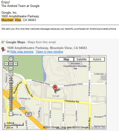
Gmail added a new Labs feature that parses your messages and lets you preview some content using web services. This time you can preview the addresses from a message using Google Maps. The addresses extracted by Gmail are displayed after a message and you can load a map preview without opening a new page. Right now, the feature only works for US addresses, but Google promises to address this issue.


Gmail already displays addresses from messages in the right sidebar, but you need to click on a link to open the map in a new page. The new Gmail Labs feature has another advantage: it also previews links to Google Maps.

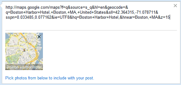
Gmail's blog says that a map preview feature is now available for Google Buzz, but it only works when you paste a Google Maps link in a Buzz message. Unfortunately, Google's thumbnails is really small and clicking on the thumbnail opens a static map.


To find the Labs feature, open Gmail Labs and use your browser's find-on-page feature (Ctrl+F / Cmd-F) to search for "Google Maps previews". Gmail Labs offers other similar contextual gadgets for previewing links to Flickr, Picasa Web, Yelp, Google Voice messages, Google Docs and the YouTube preview feature is enabled by default. Developers can create custom contextual gadgets for Gmail in Google Apps and hopefully the APIs will be extended to the regular Gmail app.